The People's Republic of Bangladesh
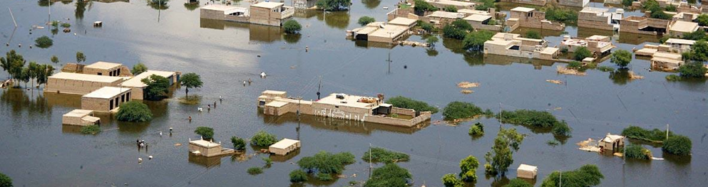
Bangladesh is a South Asian country located in between Myanmar and India on the Ganges Delta. Geographically, Bangladesh is one of lowest-lying countries in the world. Owing to this, the country is prone to floods which often encompass large parts of Bangladesh. Being located in Southeast Asia where tropical storms are common, Bangladesh residents and their homes are often the victim of torrential rain and winds which are capable of reaching up 140mph, which consequently results in waves that can rise to 26 feet tall which crash into coastal areas. It is also one of the wettest countries, with most cities receiving more than 1.5 meters of rain annually, and up to 5 meters in high regions. With this in mind, it is no surprise that flooding in Bangladesh is devastating.

Natural Causes & Effects of Flooding in Bangladesh
There are a wide range of natural causes that affect the size, impact, and scale of the floods experienced in Bangladesh. First and foremost, Bangladesh's geographical location increases its flood susceptibility. Bangladesh is a South Asian country that has two very powerful main rivers flowing through it, the river Ganges and river Brahmaputra. The discharge of those rivers is further increased due to the precipitation that Bangladesh experiences. For example, snow from the Himalayas melts during the spring time, and combines itself with periods of heavy rain, causing both the rivers to experience their peak flows at the same time, subsequently leading to flooding. Bangladesh is also an extremely low lying country--more than 70% of Bangladesh lies just 1 meter above sea level. This makes most of the country a floodplain which water can easily intercept.
In addition, the density of a place's drainage basin, which is determined by its length divided by its area, affects its flood susceptibility. That is to say, drainage basins with higher densities are more prone to flooding. The Ganges-Brahmaputra basin is among the larger world drainage basins, and is significantly dense given its size, covering an area exceeding 1.6 million square km, and with an overall length of almost 4000 km. In accordance with its location, Bangladesh's tropical climate entails a monsoon season that typically lasts from May to September. Heavy wind and torrential rain often lead to overflow of the rivers, i.e, flooding.
In addition, the density of a place's drainage basin, which is determined by its length divided by its area, affects its flood susceptibility. That is to say, drainage basins with higher densities are more prone to flooding. The Ganges-Brahmaputra basin is among the larger world drainage basins, and is significantly dense given its size, covering an area exceeding 1.6 million square km, and with an overall length of almost 4000 km. In accordance with its location, Bangladesh's tropical climate entails a monsoon season that typically lasts from May to September. Heavy wind and torrential rain often lead to overflow of the rivers, i.e, flooding.
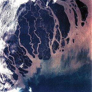
The Ganges-Brahmaputra delta: The world's largest delta
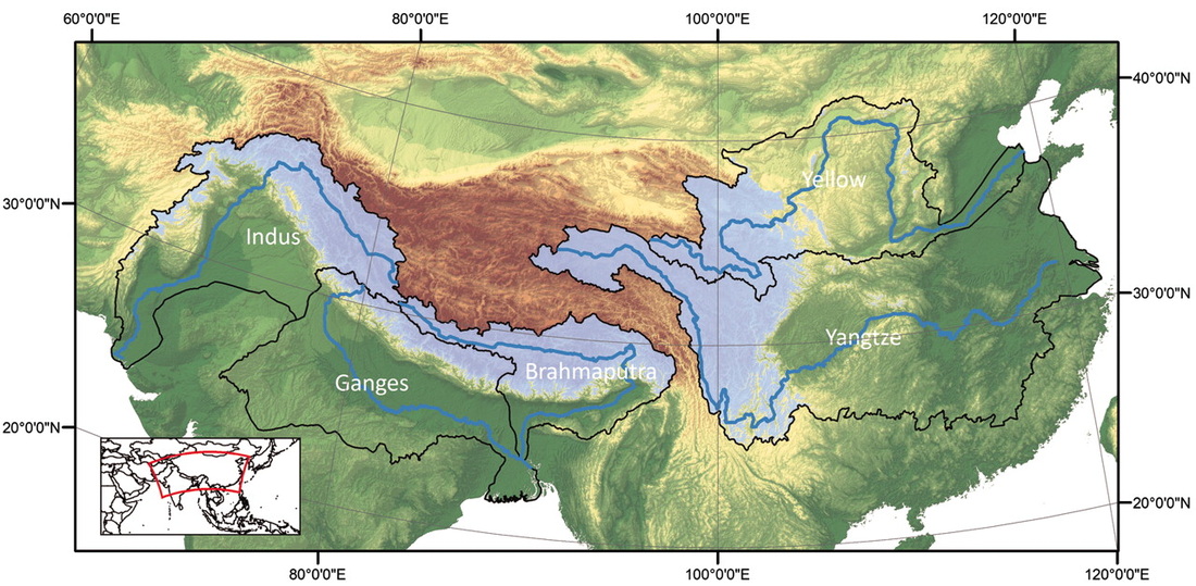
The Ganges-Brahmaputra Basin

Human Causes & Effects of Flooding in Bangladesh
Bangladesh's flood vulnerability is further jeopardized due to its human activity. On a global scale, climate change/global warming is a phenomenon thought by many to be caused by human activity. The earth's warming has intensified the natural causes of flooding in Bangladesh. For example, precipitation occurs at a faster rate: snowmelt in the Himalayas takes place at a more rapid pace, and there is a greater amount of rainfall in Bangladesh. Nationally, Bangladesh is a less economically developed country, with nearly half (49%) of the Bengal population living in poverty on less than $1 USD per day. As a whole, the country experiences both urban and rural poverty, and faces problems such as poor infrastructure. Because of its impoverished state, Bangladesh cannot afford proper flood defense services, making flooding an even more serious and dangerous matter. The issue is raised even more due to Bangladesh's increasing population. Bangladesh is one of the most densely populated countries as well as the 8th most populous country in the world with over 161 million inhabitants (est. 2012).
With more people means a greater need for housing, complexes, and building things in general. Urbanization in Bangladesh's drainage basin areas increases the risk of flooding, as water cannot infiltrate impermeable surfaces, like pavements. This increases its chance of flooding, as surface runoff is increased and hence infiltration decreased, and it can cause heavy rainfall to collect and remain without being soaked up/drained.
The people of Bangladesh need water to survive, therefore more fresh water needs to be supplied. Due to its increase in population, more than 100,000 new water wells have been constructed in Bangladesh by means of boring and drilling into the earth to access groundwater. As a result of the well installations, Bangladesh's water table has been lowered, making it more at risk for flooding. Its land now sinks about 25 mm annually.'
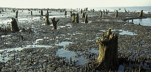
In order for construction as previously mentioned to take place, land must be cleared off. Deforestation increases risks of flooding, as less evapotranspiration can take place since there is no vegetation available to undergo it, meaning there is nothing to intercept the water so moisture cannot be returned to the atmosphere. Additionally, plant roots absorb and store water, and after deforestation no roots are able to protect the bare soil. This causes the soil to wash away, resulting in faster surface runoff, soil erosion, and a higher flood susceptibility. Most ecologists state that forests in habitable environments should make up at least 25% of the total land. However, only 16% of Bangladesh is made up of forested area, and every year, more than 2600 hectares of land are deforested in Bangladesh.
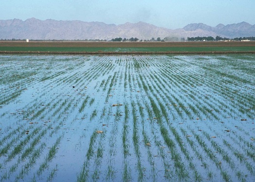
Irrigation is another manmade impact that is intensifying flood risks. Irrigating water causes a river's channels to clog up with sediment, limiting their potential to contain flood water. The river Ganges has been deflected for irrigation intentions, and as a result the sediment carried within the rivers load is removed, making it unable to form the floodplain.
With more people means a greater need for housing, complexes, and building things in general. Urbanization in Bangladesh's drainage basin areas increases the risk of flooding, as water cannot infiltrate impermeable surfaces, like pavements. This increases its chance of flooding, as surface runoff is increased and hence infiltration decreased, and it can cause heavy rainfall to collect and remain without being soaked up/drained.
The people of Bangladesh need water to survive, therefore more fresh water needs to be supplied. Due to its increase in population, more than 100,000 new water wells have been constructed in Bangladesh by means of boring and drilling into the earth to access groundwater. As a result of the well installations, Bangladesh's water table has been lowered, making it more at risk for flooding. Its land now sinks about 25 mm annually.'
In order for construction as previously mentioned to take place, land must be cleared off. Deforestation increases risks of flooding, as less evapotranspiration can take place since there is no vegetation available to undergo it, meaning there is nothing to intercept the water so moisture cannot be returned to the atmosphere. Additionally, plant roots absorb and store water, and after deforestation no roots are able to protect the bare soil. This causes the soil to wash away, resulting in faster surface runoff, soil erosion, and a higher flood susceptibility. Most ecologists state that forests in habitable environments should make up at least 25% of the total land. However, only 16% of Bangladesh is made up of forested area, and every year, more than 2600 hectares of land are deforested in Bangladesh.
Irrigation is another manmade impact that is intensifying flood risks. Irrigating water causes a river's channels to clog up with sediment, limiting their potential to contain flood water. The river Ganges has been deflected for irrigation intentions, and as a result the sediment carried within the rivers load is removed, making it unable to form the floodplain.
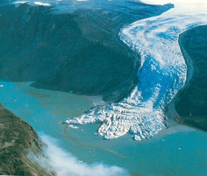
Glaciers in the Himalayas
Deforested land
Irrigated fields
Real Life Bangladesh Flood Case & Relief Measures
Taking place from August to September, the 1988 Bangladesh flooding was catastrophic, lasting a total of 20 days. It occurred mainly due to the severe monsoonal rain which occurred during those two months. Aided by Bangladesh’s geography, rivers were quickly filled to their banks by the heavy rainfall, and the water flooded the lands. The reason why the floods were not an isolated incident was owing to the fact that Bangladesh is home to four vast rivers; the River Ganges, the River Megna, the River Jamuna, and the River Brahmaputra, all of which flow into the Bay of Bengal. Furthermore, Despite the many flood prevention structures built, they are ironically destroyed by the floods which have the ability to reach far, as proven by the 1988 flood which swamped 57% of Bangladesh.
Bangladesh does, however, have some coping measures of floods. Since 1947, 7500 km of flood embankments have been built. Shelters have also been built for victims of floods. Furthermore, several ideas of the construction of dams, embankments and flood retention basins similar to the Rhine were proposed, however the costs of building these preventive measures were too high, and could not be afforded by the Bangladeshi government. This indicates that lack of money in general is the primary cause of the intensity of floods in Bangladesh, and because Bangladesh is not able to cope efficiently with flooding, the effects of floods are magnified.
Bangladesh does, however, have some coping measures of floods. Since 1947, 7500 km of flood embankments have been built. Shelters have also been built for victims of floods. Furthermore, several ideas of the construction of dams, embankments and flood retention basins similar to the Rhine were proposed, however the costs of building these preventive measures were too high, and could not be afforded by the Bangladeshi government. This indicates that lack of money in general is the primary cause of the intensity of floods in Bangladesh, and because Bangladesh is not able to cope efficiently with flooding, the effects of floods are magnified.
