The Netherlands
The Netherlands consists of twelve provinces in North-West Europe and three islands in the Caribbean. It is a low-lying country, with 50% of its area less than one meter above sea level. Most of the country is very flat, with the exception of foothills and several low hill ranges in the far southeast and in the central parts. Moreover, the country is divided into two main parts by three large rivers, the Rhine, Meuse and Scheldt. The Netherlands has a moderate maritime climate, with cool summers and mild winters. Precipitation is distributed relatively equally throughout the year, receiving about 800mm of precipitation annually.

Much of the flooding in the Netherlands occurs due to its physiological features and natural causes
Natural Causes and Effects of Flooding in the Netherlands
There are many factors that affect the size, scale and impact of floods in The Netherlands. The Netherlands' geographical location gives it an extremely high possibility of flooding. Three large rivers flow into the Netherlands, including the Rhine, the Waal and the Meuse. The discharge of the rivers can be increased due to several factors. Firstly, the rapidly melting snow in the Alps is transferred to rivers as surface runoff. Secondly, precipitation in the Netherlands, which occurs throughout the year, may overflow rivers, especially when heavy rains and storms occur. The Netherlands is also a low-lying country, as 50% of its area is only one meter above sea level, while 20% of its area is located below sea level. This makes the land more prone to flooding, since the water can easily quickly downwards through surface runoff.
Additionally, the density of the drainage basin of the area, which is determined by its length divided by the area, affects
its flood susceptibility, as drainage basins with higher densities are more prone to flooding. With an average discharge of more than 2000m3/s, a length of 1233km and an area of 197100 km2, it is quite a large drainage basin, with a relatively high density, making the Netherlands an obvious victim of flooding. Furthermore, because the Netherlands is the most downstream region of the Rhine basin, it experiences the most river discharge since it is affected by the other six countries in the basin as well.
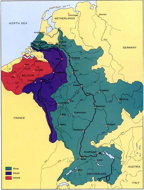
The extent of the three main drainage basins of the Netherlands

Human Causes and Effects of Flooding in the Netherlands
The Netherlands' flood vulnerability is further jeopardized due to human interference with its drainage basin system. On a global scale, climate change/global warming is a phenomenon thought by many to be caused by human activity. The earth's warming has intensified the natural causes of flooding in the Netherlands. For example, precipitation occurs at a faster rate: snowmelt in the Alps takes place at a more rapid pace, and the warmer climate increases the rate of evapotranspiration, resulting in more precipitation, increasing the discharge of the rivers. Furthermore, because the Rhine basin is extremely large and passes through six other countries aside from the Netherlands, there are many flood protection measures installed upstream, such as higher embankments. This makes floodwater travel downstream more quickly, increasing the chances of a flood due to overflow of the river.
In addition, over the years, navigation has been improved for shipping. This has involved the straightening of the Rhine river, which shortens the journey of 1320 km from source to sea by 50km. This is another factor that makes water move downstream more quickly. Furthermore, the rapidly increasing population has lead to more irrigation, urbanization and deforestation. Irrigating water causes the rivers' channels to clog with sediment, limiting their potential to contain floodwater. Such irrigation takes out the sediment carried with the river's load, making it unable to form the floodplain, which is why floods sometimes spread further inland. However, it also lowers the water table, which allows more infiltration to occur, slightly decreasing the chances of flooding.
Because of urbanization, there is less vegetation to slow down the flow of water, and it increases the chances of soil erosion. Furthermore, there is an increase of impermeable surfaces, such as parking lots, roads, etc, which increase the amount of surface runoff into rivers and decrease infiltration Lastly, deforestation, involving the cutting down of vegetation, decreases the amount of interception, resulting in more surface runoff. It also slows down the rate of evapotranspiration, since less transpiration will occur due to the decreased amount of vegetation.
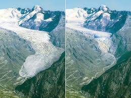
Melting glaciers in the Alps.
The River Rhine Flooding of 1995
Throughout Europe in 1995, there was a heavy downpour, some of it continuing over days, and most of it occurred over Northern regions of Europe, especially in the Netherlands. This constant torrent of rain caused rivers and streams in the Netherlands to overflow, and, coupled with the early and rapid melting of the the Alps, caused various regions in the Netherlands to become flooded. While the River Rhine Floods, when compared to the 1988 flood in Bangladesh seems like a small incident (the River Rhine flooding caused four deaths whereas the Bangladesh flooding resulted in nearly 5,000), this was only due to the preventive and relief measures taken by the Dutch government.
The Dutch government has taken a vast amount of preventative measures of flooding. Its short-term measures include the installation of portable pumps to get rid of excess water. Furthermore, they make use of sandbags, temporary barriers across doors and windows and seal doors and window frames with putty or foam to prevent floodwater from entering into people's homes. There are also several effective long term preventive measures, including the construction of flood retention basins. These are areas of riverside lands enclosed with dykes. Floodwater is directed onto these dykes in an attempt to reduce the river's level. These dykes are lined with stoned blocks and reinforced with steel piling to reduce erosion and abrasion. This effective system was built after the flood in 1953 drowned 1800 people, costing the Dutch government 6 billion Euros. Furthermore, the Netherlands recognizes the need for international cooperation in managing the Rhine basin to control flooding in the river's valley, since six other countries are involved in the same drainage basin. In addition, afforestation in the Rhine drainage basin is encouraged, because it will increase interception.
The Dutch government has taken a vast amount of preventative measures of flooding. Its short-term measures include the installation of portable pumps to get rid of excess water. Furthermore, they make use of sandbags, temporary barriers across doors and windows and seal doors and window frames with putty or foam to prevent floodwater from entering into people's homes. There are also several effective long term preventive measures, including the construction of flood retention basins. These are areas of riverside lands enclosed with dykes. Floodwater is directed onto these dykes in an attempt to reduce the river's level. These dykes are lined with stoned blocks and reinforced with steel piling to reduce erosion and abrasion. This effective system was built after the flood in 1953 drowned 1800 people, costing the Dutch government 6 billion Euros. Furthermore, the Netherlands recognizes the need for international cooperation in managing the Rhine basin to control flooding in the river's valley, since six other countries are involved in the same drainage basin. In addition, afforestation in the Rhine drainage basin is encouraged, because it will increase interception.
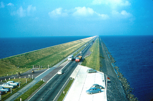
Flood Prevention Dykes
